Aerial Imaging Market Size, Share & Industry Analysis, By Platform (Aircraft, Helicopters, and Drones/UAVs), By Type (On Demand and Subscription-Based), By Service Type (Imagery Service and Analytical Solutions), By Technique (Oblique and Vertical), By End Use (Real Estate & Architecture, Agriculture, Insurance, Environmental & Conservation (Urban Planning), Commercial & Advertising, and Others), and Regional Forecast, 2026-2034
Aerial Imaging Market Analysis
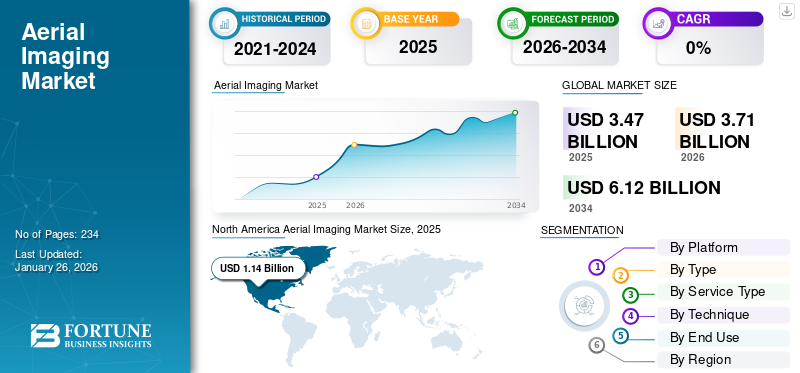
The global aerial imaging market size was valued at USD 3.47 billion in 2025. The market is anticipated to grow from USD 3.71 billion in 2026 to USD 6.12 billion by 2034, exhibiting a CAGR of 6.46% over the forecast period. North America dominated the aerial imaging market with a market share of 33.00% in 2025.
Aerial imaging refers to the process of capturing images of the Earth's surface from an airborne platform, such as an aircraft, drone, or satellite. This technique has evolved significantly since its inception and is widely used for various applications, including mapping, surveying, environmental monitoring, and disaster response. It is a powerful tool that provides vital insights into the Earth's surface from an aerial perspective. Its applications span multiple industries, including urban planning, agriculture, disaster management, and environmental monitoring. As technology continues to advance, the accuracy and accessibility of aerial imagery will only improve, further enhancing its utility in decision-making processes across various sectors. The market size is expected to witness substantial growth, driven by increasing demand across various sectors such as agriculture, construction, and environmental monitoring.
Download Free sample to learn more about this report.
Global Aerial Imaging Market Key Takeaways
Market Size & Forecast
- 2025 Market Size: USD 3.47 billion
- 2026 Market Size: USD 3.71 billion
- 2034 Forecast Market Size: USD 6.12 billion
- CAGR: 6.46% from 2026–2034
Market Share
- North America dominated the aerial imaging market with 33.00% share in 2025, supported by advanced technological infrastructure, significant presence of aerial imaging service providers, and rising adoption of drones and UAVs for applications such as urban planning, agriculture, and disaster management.
- By platform, Drones/UAVs held the largest share in 2023 due to their cost-effectiveness, accessibility, and ability to capture localized and high-resolution data, making them the preferred choice over manned aircraft.
Key Country Highlights
- United States: Growth driven by initiatives like the Federal Aviation Administration’s UAS test sites, increased use of aerial imagery in agriculture and construction, and federal investments in GIS mapping for infrastructure and disaster management.
- China: Rapid urbanization and the Belt and Road Initiative fuel heavy demand for aerial imaging in large-scale infrastructure development and precision agriculture applications.
- Japan: Strong emphasis on high-accuracy imaging for earthquake-resistant infrastructure projects and stringent environmental compliance regulations support market expansion.
- Germany (Europe): Adoption supported by mature drone regulations, growing smart city projects, and EU sustainability mandates encouraging aerial imagery for energy-efficient urban planning.
Aerial Imaging Market Trends
Increased Demand for Geospatial Analytics
Drones are being used increasingly as ideal tools for the collection of ground data. Unlike satellites, drones are capable of capturing data on a more localized and granular level. The primary means of collecting and generating mapping and navigational information for the globe. However, satellites are effective on a larger scale. There is a rise in the popularity in use of drones for smaller-scale applications, such as detailed and intricate locations. Drones can survey areas for events, such as festivals or conventions, helping organizers manage layouts effectively. After disasters, drones are being used to assess damage without putting personnel at risk, providing crucial data for insurance and recovery efforts. Farmers use drones to monitor crop health and identify issues across large fields efficiently. Drones help map airspace and determine elevations of landmarks, contributing to various planning efforts. Smaller communities utilize drones for detailed mapping, which may not be feasible with satellite imagery alone.
- North America witnessed aerial imaging market growth from USD 1.14 billion in 2025 to USD 1.20 billion in 2026.
Download Free sample to learn more about this report.
The North American aerial imaging market is characterized by rapid growth and the region has a significant market share. Aerial imaging is increasingly utilized for a wide range of applications, including geospatial mapping, urban planning, agriculture, insurance, and defense. The ability to provide detailed insights into land use, crop health, and infrastructure conditions has made aerial imagery an invaluable tool for businesses and government agencies.
The COVID-19 pandemic had a significant negative impact on the market, disrupting supply chains and slowing down new product deliveries from major drone and UAV manufacturers. However, as restrictions eased, the market began to recover due to a surge in demand for aerial imagery across various sectors, driven by its applications in urban planning, disaster management, and environmental monitoring.
Aerial Imaging Market Growth Factors
Increase in Application of Aerial Imaging in Various Industries to Augment Market Growth
Aerial imagery includes taking pictures of the images of the surface of Earth from an elevated perspective with the help of aircraft or drones. This technique gives detailed visuals of landscapes, sites, and features of the ground. Aerial imagery is increasingly being used in numerous industries.
In urban planning, aerial imaging helps city planners to conduct detailed analysis of infrastructure, growth planning, and optimizing traffic flow. For the agriculture industry, aerial imagery is used in precision farming to monitor crop health, detect pests, and enhance irrigation practices, improving yields and resource efficiency.
Environmental monitoring relies on drones for photogrammetry to track changes, assess the impact of natural disasters, and study ecosystems. Infrastructure maintenance benefits from aerial inspections, identifying potential issues, and ensuring the safety of critical structures. In disaster response, rapid and detailed assessments of affected areas are facilitated by aerial imagery, guiding emergency efforts and recovery plans.
Aerial imagery also plays a key role in cartography and mapping, contributing to accurate navigation and land use planning. Scientific research in fields, such as geotechnics, geology, ecology, and archaeology utilizes high-resolution aerial images to analyze terrain, vegetation mapping, and discover archaeological sites. Therefore, the aerial imaging market report highlights that aerial imaging is being used as a significant tool in various sectors that provides valuable insights for decision-making, planning, and research across diverse sectors.
Surge in Demand for Advanced Data Analytics and Shift toward Subscription Models to Propel Market Growth
There is a rise in the integration of advanced analytics into aerial imaging services, which provides deeper insights and more actionable data. Companies in the aerial imaging industry are increasingly offering analytics solutions that process aerial imagery to provide valuable information for decision-making. This critical analytical information is used in sectors, such as agriculture, urban planning, and disaster management. This capability helps to increase the value proposition of aerial imagery, making it more attractive to potential users. Moreover, customers are now shifting toward subscription services that allow businesses to access this type of imaging data and analytics on a flexible basis. It saves customers from making significant upfront investments in direct purchasing the imagery. Market players, such as Nearmap and Hexagon, offer cloud subscription options to deliver unlimited access to aerial imagery for a certain period. This model can lower barriers to entry for smaller companies and startups, fostering wider adoption across various industries. Subscription services also ensure continuous revenue streams for providers, encouraging them to invest in better technology and services. All these factors are expected to drive the market growth.
Technological Advancements Acting as a Catalyst for Market Growth
The market is experiencing technological advancements in various systems used to capture aerial imagery. The incorporation of artificial intelligence (AI) and machine learning into drone technology allows for autonomous operations, such as object recognition, obstacle avoidance, and path planning. Such advancements in drone technology improve their performance over time by analyzing data and learning from previous flights, making them more efficient in capturing relevant imagery without manual input. There is also an increase in demand for drones that are installed with specialized sensors, such as thermal imaging and multispectral sensors. These technologies are particularly high in demand in sectors, such as agriculture for monitoring crop health and detecting pests, as well as in emergency services for search and rescue operations.
RESTRAINING FACTORS
High Equipment and Maintenance Costs Hamper Market Growth
High-quality aerial imagery requires advanced technology, such as drones and aircraft equipped with high-quality cameras, sensors, and other systems. The cost of the equipment is substantially high. Moreover, companies are also needed to install sophisticated software for image processing and analytics. Licensing fees for these software solutions can add significantly to the overall cost.
The costs related to drone imagery and its services reflect the complexity and expertise required to conduct various operations effectively. For instance, drone inspections typically start at approximately USD 1,499, but this price can vary depending on the type of inspection and the equipment used. The specific nature of the inspection, the technology deployed, and the accessibility of the site are some of the factors that decide the cost of surveying and mapping. Drone-based mapping operations are charged on a per-acre basis. The clients generally are expected to pay between USD 60 and USD 160 per acre. The change in pricing is affected by various characteristics, such as the difficulty level of the project and the characteristics of the terrain.
Aerial Imaging Market Segmentation Analysis
By Platform Analysis
Drones/UAVs Held the Largest Share in 2023 Due to Their Cost-effectiveness and Accessibility
On the basis of platform, the market is classified into drones/UAVs, aircraft, and helicopters.
The drones/UAVs segment is poised to account for 44.91% of the market share in 2026 due to their benefits, such as cost-effectiveness and accessibility. Drones are less expensive to purchase and operate than manned aircraft, as they require lower fuel costs and lower maintenance expenses. Moreover, the advantages, such as the flexibility to reach remote and complicated areas, make them a popular choice for capturing images.
- The aircraft segment is expected to hold a 32.2% share in 2023.
The helicopters segment is expected to grow faster during the forecast period owing to the rise in demand for helicopter surveying in disaster response for emergency medical services. Helicopters with aerial imaging technologies are preferred in rapid medical response situations to support activities, such as transporting patients from accident areas.
To know how our report can help streamline your business, Speak to Analyst
By Type Analysis
On Demand Segment Held the Largest Share in 2023 Due to Rise in Demand for Constant Access to High-Quality Imagery
On the basis of type, the market is classified into on demand and subscription-based.
The on-demand segment is expected to lead the market, contributing the largest market share in 2026 with 58.17% as businesses and the commercial sector look for specific aerial imaging solutions tailored according to their unique requirements. Such services allow customers to access high-quality imagery without having to make long-term contracts or commitments with the company. This flexibility appeals to a wide range of sectors, including agriculture, construction, and real estate, where specific projects may require distinct imaging capabilities. Moreover, the increasing popularity of resellers and marketplaces that allow customers to compare different aerial imaging services easily and select specific offerings based on their needs contributes to the growth of the segment.
The subscription-based segment is expected to grow the fastest in the market owing to an increase in the need for continuous access to high-quality aerial imagery. Numerous industries, such as agriculture, real estate, and construction, require regular monitoring and constant updates of their projects. Companies provide timely and regular aerial imagery to such industries with the help of annual or monthly subscription models. Moreover, subscription services often include analytics tools that help users derive insights from the data collected, enhancing their operational capabilities.
By Service Type Analysis
Imagery Service Segment Held the Largest Share in 2023 Due to Widespread Adoption of Drones and Advanced Aerial Platforms
On the basis of service type, the market is classified into imagery service and analytical solutions.
The imagery service segment is expected to account for the largest market share in 2026, with 63.90%, and is growing significantly due to the extensive adoption of drones and advanced aerial platforms. Various sectors, including agriculture, construction, and environmental monitoring, understand the advantages of aerial imagery for tasks, such as surveying, mapping, and inspections. These industries are increasingly integrating these services into their operations. High-resolution images captured with the help of these services allow businesses to make informed decisions based on real-time data. Therefore, the adoption of aerial imagery in various sectoral applications is expected to drive the growth of the segment.
Analytical solutions is the fastest-growing segment as a large number of companies utilize various imagery data-driven decision-making. There is a surge in the focus on real-time analytics, which acts as a driver of growth in this segment. As industries are in search of immediate insights from aerial data, such as monitoring construction progress or assessing environmental changes, the demand for analytical solutions is expected to increase during the forecast period.
By Technique Analysis
Oblique Segment Accounted For the Largest Market Share in 2023 Due to Its Benefits
On the basis of technique, the market is classified into oblique and vertical.
The oblique segment is expected to emerge as the leading segment with a 66.91% share in 2026 and is growing significantly due to the benefits provided by oblique imagery, such as comprehensive and detailed visual information. Oblique imagery is images captured at angles typically between 40 to 60 degrees. This type of imagery provides a more realistic representation of structures and landscapes. This perspective enables users to see not only the top surfaces but also the sides of buildings and other vertical features. The oblique imagery is needed for urban planning, real estate, infrastructure assessments, and other applications.
The vertical is the fastest-growing segment as there is an increase in the adoption of aerial imagery especially vertical imagery in the agriculture sector. Vertical imagery, also called overhead imagery, is popular among farmers and agronomists for applications, such as crop monitoring, land change detection, land use analysis, and others. Moreover, government agencies utilize vertical images for mapping purposes, disaster response planning, and environmental studies.
By End Use Analysis
Real Estate & Architecture Segment Held the Largest Share in 2023 Due to Increase in Demand for High-Quality Visual Content in Property Marketing
Based on end use, the market segmentation is real estate & architecture, agriculture, insurance, environmental & conservation, commercial & advertising, and others.
The real estate & architecture segment is set to dominate the market, holding market share in 2023, and is growing significantly due to the rise in demand for high-quality visual content in property marketing. Aerial imagery provides high-quality views of properties along with their surroundings. As real estate agents and developers understand the importance of aerial photography in attracting clients, they are increasingly incorporating these services into their marketing strategies. Moreover, the use of 3D modeling and mapping is gaining traction in architecture, which is expected to propel the growth of the segment.
Agriculture is the fastest-growing segment owing to the surge in utilization of aerial imagery in precision agriculture practices. Aerial imagery has become significant for farmers to monitor crop health, analyze soil conditions, and optimize resource usage. High-resolution multispectral images give a detailed analysis of changes in crop growth across fields. Such analysis helps farmers to make data-driven decisions regarding irrigation, fertilization, and pest management.
REGIONAL INSIGHTS
The global market is segmented on the basis of region into North America, Europe, Asia Pacific, Latin America, and Middle East & Africa.
North America Aerial Imaging Market Size, 2025 (USD Billion)
To get more information on the regional analysis of this market, Download Free sample
North America
In 2025, the North America market stood at USD 1.14 billion, representing 33.00% of global demand, and is projected to grow to USD 1.2 billion in 2026. The aerial imaging market share is dominated by North America as the region holds a significant portion in the market owing to the presence of major service providers and advanced technological infrastructure. The rise in the adoption of drones and unmanned aerial vehicles (UAVs) for data collection is a key driver for the growth of the market in the region. Moreover, government initiatives, such as the Federal Aviation Administration's establishment of UAS test sites, are promoting the integration of aerial imaging technologies in sectors, such as agriculture, construction, and defense. The demand for high-resolution imagery for urban planning and disaster management further provides growth opportunities for the market in this region. As organizations increasingly adopt Geographic Information Systems (GIS) maps for analyzing aerial data, the demand for aerial imaging services is expected to rise, thereby driving market growth. In addition, presence of companies such as EagleView Technologies, Digital Aerial Solutions LLC, Cooper Aerial Surveys Co., and others that specialize in providing aerial surveying and mapping services is expected to propel the global aerial imaging market growth in the region.
- The U.S. market is projected to reach USD 0.95 billion by 2026.
Asia Pacific
Asia Pacific maintained a strong presence in the global market, reaching USD 0.81 billion in 2025, accounting for 23.23% share, and is expected to reach USD 0.88 billion in 2026. The growth of the market in the region is fueled by rapid urbanization and infrastructure development in countries, such as China, India, and Indonesia. The demand for aerial imaging services is on the rise as these nations invest heavily in transportation networks and smart city projects. In addition, the growing adoption of precision agriculture practices is driving the need for high-quality aerial imagery to monitor crop health and optimize resource use. The region's relatively untapped potential presents significant opportunities for both local and global players. The Japan market is projected to reach USD 0.13 billion by 2026, the China market is projected to reach USD 0.34 billion by 2026, and the India market is projected to reach USD 0.18 billion by 2026.
Europe
The Europe region captured 32.15% of the global market in 2025, generating USD 1.12 billion in revenue, and is projected to reach USD 1.2 billion in 2026. In Europe, the market is experiencing steady growth primarily due to the increasing demand for high-resolution imagery in sectors such as infrastructure and real estate. Countries such as the U.K., Germany, and France are leading this growth, supported by a mature regulatory framework that facilitates drone usage.
- The UK market is projected to reach USD 0.38 billion by 2026, while the Germany market is projected to reach USD 0.35 billion by 2026.
Latin America
In 2025, Latin America represented USD 0.18 billion, accounting for 5.19% of the worldwide market, and is projected to grow to USD 0.19 billion in 2026. Latin America's market is on an upward trajectory, driven by growing awareness of the benefits of aerial imaging technology for applications in agriculture, urban planning, and disaster management. The region is seeing a rise in investments in drone technology and geospatial projects, which are essential for improving agricultural productivity and infrastructure development.
Middle East & Africa
The Middle East & Africa market accounted for USD 0.22 billion in 2025, representing 6.43% of the global industry, and is expected to reach USD 0.24 billion in 2026. In addition, the Middle East & Africa region is expected to experience a surge in demand for surveillance, monitoring, and urban planning solutions, which will drive the growth of the market in the region.
KEY INDUSTRY PLAYERS
Key Players Focus on the Development of Technologically Advanced Products and Acquisition Strategies to Drive Growth
The prominent market players are prioritizing the advancement of their service offerings. The development of a diverse range of solutions and heightened investment in research and development are key factors contributing to the market dominance of these players. Within the industry, major players, such as survey mapping service providers and aerial imagery and analytics suppliers are embracing both organic and inorganic growth approaches, including mergers and acquisitions as well as the introduction of new products, to sustain their competitive edge.
LIST OF TOP AERIAL IMAGING COMPANIES
- Nearmap Inc. (Australia)
- EagleView Technologies Inc. (U.S.)
- Vexcel (Austria)
- Hexagon (Sweden)
- Fugro (Netherlands)
- Bluesky International Ltd (U.K.)
- Digital Aerial Solutions LLC (U.S.)
- Cooper Aerial Surveys Co. (U.S.)
- Landiscor Real Estate Mapping (U.S.)
- Kucera International Inc. (U.S.)
- Aeroptic, LLC (U.S.)
- Global UAV Technologies Ltd. (High Eye Aerial Imaging Inc.) (Canada)
KEY INDUSTRY DEVELOPMENTS
- October 2024- Vexcel conducted a large-scale aerial imagery collection in response to Hurricane Milton, which made landfall as a Category 3 storm on October 9, 2024. This initiative is part of Vexcel's Gray Sky Program, aimed at providing high-resolution imagery and damage assessments to support recovery efforts following natural disasters.
- June 2024- Vexcel and CAPE Analytics announced a strategic partnership aimed at enhancing property insights through high-resolution aerial imagery. This collaboration is set to significantly improve CAPE's capabilities in delivering predictive property risk analytics across the U.S., Canada, and Australia.
- December 2023- Nearmap announced the acquisition of Betterview, a property intelligence and risk management platform tailored for the insurance industry. This acquisition marks a significant step in Nearmap's strategy to enhance its offerings and strengthen its position as a leading provider of imagery intelligence and data solutions.
- March 2023- UP42 partnered with Vexcel to enhance its aerial imagery and geospatial data offerings on its marketplace. This collaboration aims to provide high-resolution and accurate geospatial data products across more than 30 countries, including the U.S., Canada, the U.K., Europe, Australia, New Zealand, and Japan.
- April 2022- Nearmap announced a partnership with UP42 to provide high-resolution aerial imagery, specifically the Nearmap vertical imagery, to customers across major urban areas in the U.S., Canada, Australia, and New Zealand. This collaboration aims to enhance access to detailed geographic insights for various applications, particularly in sectors, such as utilities, construction, and local government.
REPORT COVERAGE
The report provides a detailed analysis of the sector and focuses on important aspects such as key players, component, platform, end-user, and applications depending on various regions. Moreover, the research report offers deep insights into the aerial imaging market trends, competitive landscape, market competition, aerospace and defense PCBs product pricing, and market status and highlights key industry developments. Also, it encompasses several direct and indirect factors that have contributed to the sizing of the global market in recent years.
Request for Customization to gain extensive market insights.
Report Scope & Segmentation
|
ATTRIBUTE |
DETAILS |
|
Study Period |
2021-2034 |
|
Base Year |
2025 |
|
Estimated Year |
2026 |
|
Forecast Period |
2026-2034 |
|
Historical Period |
2021-2024 |
|
Unit |
Value (USD billion) |
|
Growth Rate |
CAGR of 6.46% from 2026 to 2034 |
|
Segmentation |
By Platform
|
|
By Type
|
|
|
By Service Type
|
|
|
By Technique
|
|
|
By End Use
|
|
|
By Region
|
Frequently Asked Questions
According to Fortune Business Insights, the global aerial imaging market size was valued at USD 3.47 billion in 2025 and is projected to grow from USD 3.71 billion in 2026 to USD 6.12 billion by 2034, exhibiting a CAGR of 6.46% during the forecast period.
Registering a CAGR of 6.46%, the market will exhibit significant growth over the forecast period.
The aerial imaging market is driven by the increasing use of drones and UAVs, rising demand for geospatial data in urban planning, precision agriculture, environmental monitoring, and the shift toward subscription-based analytics platforms that make high-resolution aerial data more accessible and cost-effective.
North America dominated the aerial imaging market in 2025, holding a 33.00% share, supported by advanced drone infrastructure, strong government support like FAA UAS test sites, and widespread adoption across agriculture, construction, and disaster management applications.
Aerial imaging is used for urban planning, agriculture (crop monitoring, irrigation efficiency), environmental conservation, disaster response, infrastructure inspections, insurance assessments, mapping and cartography, and real estate marketing.
Drones/UAVs held the largest platform share in 2025 due to their cost-effectiveness, accessibility, and ability to capture high-resolution data at localized levels, making them preferred over manned aircraft for various commercial and public sector applications.
Technological advancements, such as the integration of AI, machine learning, and multispectral sensors into aerial platforms, are enabling autonomous data capture, real-time analytics, object recognition, and thermal imaging, enhancing decision-making across industries like agriculture, infrastructure, and emergency services.
Major challenges include the high cost of drones, sensors, and analytical software, licensing fees, and complexity of data processing, which can limit adoption for smaller enterprises. Drone-based inspections can cost between USD 60–160 per acre, impacting pricing models and ROI.
The subscription-based aerial imaging segment is growing rapidly as businesses seek continuous access to updated imagery and real-time analytics. This model reduces upfront costs and provides operational flexibility, especially for industries requiring constant monitoring.
Key players in the aerial imaging market include Nearmap Inc., EagleView Technologies Inc., Vexcel, Hexagon, Fugro, Bluesky International Ltd, and Digital Aerial Solutions LLC. These companies offer advanced aerial imagery, geospatial analytics, and subscription-based platforms.
The aerial imaging market is expected to experience robust growth through 2034, driven by technological advancements, increased adoption in emerging economies, and greater integration of aerial imagery with AI-powered analytics, supporting industries like smart cities, agriculture, and disaster risk management.


- 2021-2034
- 2025
- 2021-2024
- 234
Get 20% Free Customization
Expand Regional and Country Coverage, Segments Analysis, Company Profiles, Competitive Benchmarking, and End-user Insights.
Related Reports
-
US +1 833 909 2966 ( Toll Free )
-
Get In Touch With Us