Geospatial Imaging Market Size, Share, COVID-19 Impact Analysis, By Platform (Drones, Vehicle Mounted Device, Mobile, and Backpack), By Application (Corridor Mapping, Engineering, Environment, Exploration, ADAS, and Others), By End-Use Industry (Infrastructure, Transportation & Logistics, Real Estate, Energy & Utilities, and Others) and Regional Forecast, 2026-2034
KEY MARKET INSIGHTS
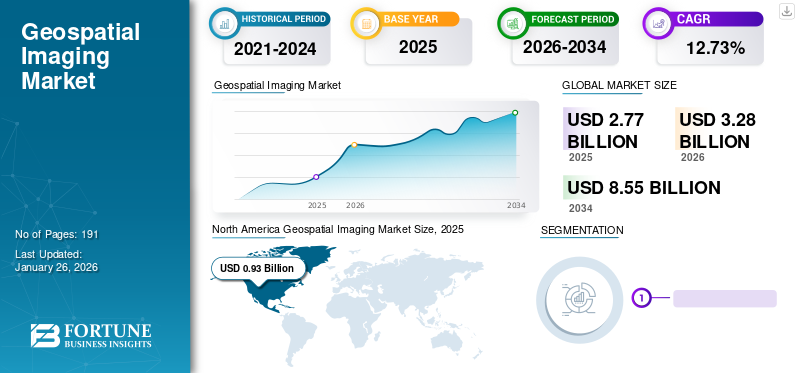
The global geospatial imaging market size was valued at USD 2.77 billion in 2025. The market is projected to grow from USD 3.28 billion in 2026 to USD 8.55 billion by 2034, exhibiting a CAGR of 12.73% during the forecast period. North America dominated the geospatial imaging market with a market share of 33.57% in 2025.
Geospatial imaging is the process of capturing, analyzing, and interpreting imagery and data of the Earth's surface and its features. It utilizes technologies such as mobile mapping systems, aerial photography, Light Detection and Ranging (LiDAR), and remote sensing. It has a wide range of applications across various end-user industries such as infrastructure, environmental monitoring, exploration, transportation & logistics, and others.
The process involves the use of specialized sensors and technologies to collect data from different sources. These sources include aircraft equipped with cameras or LiDAR sensors or ground-based systems. The collected imagery and data are processed and analyzed using advanced software and algorithms. This comprises image enhancement, geometric correction, feature extraction, classification, and spatial modeling. The rising demand for 3D maps of cities and road networks is expected to drive the geospatial imaging market growth from 2023 to 2030.
Download Free sample to learn more about this report.
COVID-19 IMPACT
COVID-19 Positively Impacted Market Due to Increased Adoption of Remote Sensing and Monitoring Capabilities
The COVID-19 pandemic increased the need for remote sensing and monitoring capabilities in various sectors, such as public health, urban planning, and disaster management. Geospatial imaging technologies played a crucial role in monitoring the spread of the virus, assessing the impact on healthcare systems, tracking population movement, and analyzing compliance with social distancing norms. Moreover, travel restrictions, lockdown measures, and safety concerns disrupted field data collection activities for geospatial imaging projects. Aerial surveys, on-site mapping, and data acquisition faced delays or cancellations, affecting project timelines and data availability. However, most of the aerial survey requirements were fulfilled with the help of satellite imagery. Furthermore, the pandemic created opportunities in healthcare and crisis management. From identifying high-risk areas to optimizing healthcare resource allocation, geospatial imaging services offered valuable insights and support in managing the crisis.
Geospatial Imaging Market Overview & Key Metrics
Market Size & Forecast
- 2025 Market Size: USD 2.77 billion
- 2026 Market Size: USD 3.28 billion
- 2034 Forecast Market Size: USD 8.55 billion
- CAGR: 12.73% from 2026–2034
Market Share
- North America led the geospatial imaging market with 33.57% share in 2025, driven by strong presence of service providers such as Fugro N.V., Trimble Inc., and NV5 Global Inc., and rising adoption in defense, utility, and infrastructure projects.
- Vehicle-Mounted Devices held the largest platform share due to their widespread use in infrastructure development and corridor mapping projects, while drone imaging emerged as the fastest-growing segment supported by demand in agriculture and construction.
Key Country Highlights
- United States: Adoption of advanced geospatial analytics in defense, infrastructure, and transportation, coupled with acquisitions like NV5 Global’s purchase of Axim Geospatial to expand GIS services.
- India: Rapid urban development and smart city projects, including partnerships such as Bentley Systems and Genesys International for 3D city digital twins.
- Japan: High use of geospatial imaging for disaster management and infrastructure monitoring due to frequent seismic activities.
- Germany: Strong integration of geospatial data for autonomous vehicles and environmental monitoring, driven by automotive and industrial players.
LATEST TRENDS
Integration of Artificial Intelligence (AI) & Machine Learning (ML) Techniques is a Prominent Market Trend
Technological advancements are the key trends gaining popularity in the market. Major players in the market are focusing on developing technologically advanced solutions by integrating Artificial Intelligence (AI) and Machine Learning (ML) to analyze geospatial data by automating image analysis, object detection, and change detection. AI and ML algorithms can process large datasets more efficiently. They can extract meaningful insights and automate repetitive tasks in geospatial data analysis.
Download Free sample to learn more about this report.
For instance, in September 2022, Picterra SA, a Switzerland-based geospatial imaging ML SaaS platform for detecting objects, monitoring changes, and spotting patterns in satellite, drone, and aerial imagery, introduced a groundbreaking data curation technology for geospatial imagery. The company's latest innovation enabled users to gain deeper insights into their datasets and enhance the accuracy of their models.
- North America witnessed geospatial imaging market growth from USD 0.69 Billion in 2023 to USD 0.80 Billion in 2024.
By analyzing image variability, this unique technology helped GIS and data science teams identify areas where new training data should be added to optimize model performance. Furthermore, multi-sensor integration, cloud computing & big data analytics, integration of geospatial data with the Internet of Things (IoT), and strategic partnerships and collaborations are also key trends in the market.
DRIVING FACTORS
Rising Demand for 3D Maps of Cities and Road Networks will Catalyze Market Growth
Rapid urbanization and infrastructure development projects around the globe will require accurate geospatial data for effective planning, land management, and infrastructure monitoring. 3D maps enable users to visualize their surroundings which makes it easier to identify landmarks, navigate complex road networks, and understand the spatial relationships between different factors. Geospatial imaging plays a crucial role in mapping urban areas, assessing land use patterns, and supporting infrastructure projects, such as transportation networks, smart cities, and utility planning which will propel market growth.
For instance, in September 2022, Bentley Systems, Inc., a U.S.-based infrastructure engineering software company, and Genesys International, an India-based company that offers advanced mapping and geospatial content services, announced their partnership for a 3D City Digital Twin Solution in Urban India, the first of its kind by an Indian company. Powered by Bentley's OpenCities 365, this extensive mapping and surveying project will capture a significant portion of urban India. Furthermore, navigation & location-based services, smart city initiatives, and disaster management are expected to propel the market growth.
Development of Autonomous Vehicles to Boost Geospatial Imaging Market Share
Autonomous vehicles heavily rely on accurate geospatial data for mapping, navigation, and situational awareness. They require real-time geospatial data to understand dynamic environments, such as live traffic conditions and construction zones. Unlike standard maps, which lack daily updates on construction zones and driving regulations, maps powered by specific geospatial data can provide real-time information. This includes details on parking ramp usage, thereby enhancing the user experience. The spatial data also helps autonomous vehicles to assess road networks, parking facilities, and charging stations.
For instance, in January 2022, according to BloombergNEF, a total of 21 passenger car models equipped with LiDAR were announced by 17 automakers across the world, either in production or set to be released soon. Many leading car manufacturers, including Mercedes-Benz, Nissan, BMW, Stellantis, Volkswagen, and Volvo have already expressed their plans to incorporate LiDAR into their sensor suites for Advanced Driver Assistance Systems (ADAS) and Autonomous Driving (AD) in their upcoming car models.
RESTRAINING FACTORS
Data Security, Privacy Concerns, and Higher Data Storage Requirement to Hamper Market Growth
Data security, privacy concerns, and higher data storage requirement are anticipated to hinder the market growth. Geospatial data contains confidential and valuable information. It includes information on the location of military bases, important infrastructure, and other private properties. Any breaches or unauthorized access to this data will cause serious threats to countries and organizations.
For instance, in July 2021, according to a report by cybersecurity researchers from WizCase, mapsonline.net, a website owned by PeopleGIS, a Massachusetts-based company that offers information management software to local governments in Massachusetts, New Hampshire, and Connecticut, had a security lapse. This resulted in the exposure of over 1.6 million files and more than 1,000 GB of data from various municipalities in the U.S. Furthermore, as the industry evolves and data collection methods improve, the demand for higher data storage capabilities will increase, which poses a challenge for storage infrastructure and costs.
SEGMENTATION Analysis
By Platform Analysis
Vehicle Mounted Devices to Dominate Market due to Rapid Development and Maintenance of Infrastructure
By platform, the market is categorized into drones, vehicle-mounted devices, mobile, and backpacks. The vehicle-mounted device segment will dominate the market share owing to the rapid development and maintenance of infrastructure. Vehicle-mounted devices refer to cutting-edge devices installed on a vehicle to capture detailed three-dimensional (3D) data of the surrounding environment using laser beams. The vehicle mounted device segment is projected to dominate the market with a share of 35.06% in 2026.
Drone imaging is the fastest-growing segment due to the rising demand for aerial imaging from the construction and agriculture sectors. Drone imaging refers to using UAVs (Unmanned Aerial Vehicles) equipped with cameras or sensors to capture high-resolution images or data from the air. Drone imaging is commonly used in various fields, such as surveying, construction, agriculture, and environmental monitoring for efficient and accurate data collection and analysis.
By Application Analysis
To know how our report can help streamline your business, Speak to Analyst
Corridor Mapping Applications to Gain Traction with Rising Demand for Imagery Services from Construction Sector
By application, the market is bifurcated into corridor mapping, engineering, environment, exploration, ADAS and others. The corridor mapping segment dominated the market and is expected to register significant growth during the forecast period due to the increasing demand for imagery services from construction sector. Corridor mapping refers to the process of capturing and mapping a linear area or route, such as a road, railway, pipeline, or power line. The corridor mapping segment is expected to lead the market, contributing 35.67% globally in 2026.
- The environment segment is expected to hold a 12% share in 2024.
The ADAS segment is expected to be the fastest growing segment during the forecast period due to increasing focus on vehicle safety and autonomous vehicles. Advanced Driver Assistance System (ADAS) is a technology that assists drivers in operating a vehicle more safely and efficiently. ADAS systems use sensors, cameras, and other devices to monitor the surrounding environment and provide real-time information to the driver.
By End-User Industry Analysis
Increasing Demand for Surveying and Mapping from AEC Industry to Boost Product Use in Infrastructure Industry
The market, by end-user industry, is segmented into infrastructure, transportation & logistics, real estate, energy & utilities, and others. The infrastructure segment dominated the market in the base year due to the rising demand for surveying and mapping from Architecture, Engineering & Construction (AEC) industry. Infrastructure includes roads, highways, bridges, tunnels, overpasses, rail, airports, and others. The infrastructure segment will account for 36.28% market share in 2026.
The transportation segment is expected to be the fastest-growing segment due to the rising demand for spatial information for transportation networks, infrastructure, and assets. Transportation & logistics refers to the management and movement of goods, services, and people from one location to another.
REGIONAL INSIGHTS
In terms of geography, the market is divided into North America, Europe, Asia Pacific, and the Rest of the World.
North America
North America Geospatial Imaging Market Size, 2025 (USD Billion)
To get more information on the regional analysis of this market, Download Free sample
North America contributed 33.57% to the global market in 2025, with a valuation of USD 0.93 billion, and is projected to reach USD 1.09 billion in 2026. This growth is attributed to the presence of major service providers, such as Fugro N.V., Trimble Inc., NV5 Global, Inc., ESRI Inc., and others. For instance, in March 2023, NV5 Global Inc., a company specializing in technology, conformity assessment, and consulting solutions, acquired Axim Geospatial for an undisclosed amount. This acquisition broadened NV5's expertise in the federal defense and intelligence sectors and reinforced its leadership in providing geospatial utility solutions. Axim's exceptional enterprise Geographic Information Systems (GIS) is expected to further enhance NV5's GIS capabilities by offering cloud-managed services, ensuring secure and scalable options to meet the increasing demand for GIS data and analytics. The U.S. market is estimated at USD 0.92 billion by 2026.
Europe
Europe accounted for USD 0.75 billion in 2025, representing 27.08% of the global market share, and is projected to reach USD 0.88 billion in 2026. Europe captured the second-largest market share in the base year. This market growth is due to the increasing adoption of geospatial technologies for asset management and environmental control. Moreover, the presence of major vehicle OEMs who intend to boost autonomous vehicles in European countries is also expected to propel the market growth in this region. The UK market is expected to reach USD 0.14 billion by 2026, while the Germany market is assessed at USD 0.13 billion by 2026.
Asia Pacific
The Asia Pacific market was valued at USD 0.67 billion in 2025, capturing 24.19% of global revenue, and is estimated to reach USD 0.81 billion in 2026. Asia Pacific held a significant market share in the base year and is expected to be the fastest-growing region during the forecast period. The market’s rapid growth in this region is owing to the expanding construction industry in countries, such as India, China, Japan, the Philippines, and other emerging countries. Furthermore, the rising demand for geospatial imagery analytics solutions for precision agriculture is also expected to boost market growth. The Japan market is forecast to attain USD 0.11 billion by 2026, the China market is set to reach USD 0.14 billion by 2026, and the India market is anticipated to achieve USD 0.10 billion by 2026.
Rest of The World
The Rest of the World region captured 14.80% of the global market in 2025, generating USD 0.41 billion in revenue, and is projected to reach USD 0.49 billion in 2026. The market in the rest of the world is expected to grow significantly during the forecast period. The growth is attributed to the increased adoption of geospatial imagery analytics in end-user industries such as exploration, energy, utilities, and natural resources. Furthermore, modernization and new infrastructure projects are also anticipated to drive market growth. The ROW market is valued at USD 0.49 billion by 2026.
KEY INDUSTRY PLAYERS
Drone Imaging, Emerging Markets, Technological Advancements, and Innovations are Key Focus Areas of Leading Players
The global geospatial imaging market share is relatively fragmented with key players such as Fugro N.V., Trimble, Inc., NV5 Global, Inc., ESRI Inc., Hexagon AB, Cyient Limited, Woolpert Inc., and others. Major players are focusing on drone imaging, emerging markets, technological advancements, and innovations to increase their market share. For instance, in May 2022, RailTel Corporation of India Ltd and Esri India, a provider of GIS software and solutions, signed a Memorandum of Understanding (MoU) to deliver cloud-based GIS solutions to government sector users. The collaborative offerings will encompass software, cloud infrastructure, and associated services, enabling government organizations to transition from on-premises infrastructure to cloud and GIS solutions.
LIST OF KEY COMPANIES PROFILED:
- Asia Air Survey Co., Ltd (AAS) (Japan)
- Cyient Limited (India)
- ESRI, Inc. (U.S.)
- Fugro N.V. (Netherlands)
- Hexagon AB (Sweden)
- NV5 Global, Inc. (U.S.)
- Pasco Corporation (Japan)
- Surdex Corporation (U.S.)
- Trimble, Inc. (U.S.)
- Woolpert Inc. (U.S.)
KEY INDUSTRY DEVELOPMENTS:
- April 2023 - NV5 Global, Inc., a U.S.-based company that provides technology, conformity assessment, and consulting solutions, completed the acquisition of L3Harris Technologies, Inc.'s commercial geospatial technology and software business, known as Visual Information Solutions (VIS). This strategic acquisition reinforced NV5's commitment to expand its geospatial imaging product and service offerings through a subscription-based model. It will also enhance NV5's ability to provide geospatial information management and analytics, further solidifying its support for the defense and intelligence communities.
- March 2023 - NV5 Global, Inc., a U.S.-based company that provides technology, conformity assessment, and consulting solutions, announced that its subsidiary, Axim Geospatial, LLC, had secured national security geospatial contracts worth USD 9 million from intelligence agencies and the Department of Defense. The awarded orders encompass the development and integration of reliable geospatial intelligence (GEOINT) derived from both conventional and unconventional sources.
- February 2023 - Environmental Systems Research Institute, Inc. (ESRI) introduced the ArcGIS Reality software, a cutting-edge solution for high-precision 3D mapping and digital twin creation. This platform seamlessly integrates Geographic Information Systems (GIS) with reality mapping data to generate accurate and detailed digital representations of various environments. These capabilities enable the construction industry, urban planners, and even entire nations to efficiently capture and visualize their physical landscapes using imagery data.
- February 2022 - Woolpert Inc. acquired eTrac Inc. for an undisclosed amount. eTrac Inc. is a vessel-based hydrographic survey and marine technology firm that conducts custom and integrated marine services for projects across the U.S. and its territories. The services encompass various aspects such as hydrographic surveying and bathymetric mapping data collection and processing for coastal mapping, navigation safety, and nautical charting. Additionally, underwater imagery and aerial LiDAR data are utilized for change analysis, while providing vessel positioning and monitoring services.
- September 2021 - Woolpert Inc., U.S.-based premier Architecture, Engineering, Geospatial (AEG) and strategic consulting firm acquired AAM Pty Limited for an undisclosed amount. This acquisition helped Woolpert increase its geographical presence and capabilities in mapping activities in the Asia Pacific region. AAM Pty Limited is an Australian geospatial services company that specializes in aerial mapping, surveying, GIS, and the development of innovative geospatial imaging processes and technologies.
REPORT COVERAGE
The market research report provides a detailed market analysis. It comprises all major aspects such as R&D capabilities and optimization of the operating services. Moreover, the report offers insights into the market share, trends, regional analysis, porter’s five forces analysis, and competitive landscape of various companies profiled in the report, and highlights key industry developments. In addition to the above-mentioned factors, it mainly focuses on several factors that have contributed to the global market growth in recent years.
Request for Customization to gain extensive market insights.
Report Scope & Segmentation
|
ATTRIBUTE |
DETAILS |
|
Study Period |
2021-2034 |
|
Base Year |
2025 |
|
Estimated Year |
2026 |
|
Forecast Period |
2026-2034 |
|
Historical Period |
2021-2024 |
|
Growth Rate |
CAGR of 12.73% from 2026 to 2034 |
|
Unit |
Value (USD Billion) |
|
Segmentation |
By Platform, Application, End-Use Industry, and Geography |
|
By Platform
|
|
|
By Application
|
|
|
By End-Use Industry
|
|
|
By Geography |
|
Frequently Asked Questions
As per the Fortune Business Insights study, the market size was valued at USD 2.77 billion in 2025.
The market is likely to record a CAGR of 12.73% over the forecast period of 2026-2034.
The drones segment is expected to lead the market due to the rising demand for aerial imaging solutions from construction and agriculture sectors.
The market size in North America stood at USD 12.73 billion in 2025.
The rising demand for 3D maps of cities and road networks and development of autonomous vehicles are expected to drive the market.
Some of the top players in the market are Fugro N.V., Trimble, Inc., NV5 Global, Inc., ESRI Inc., Hexagon AB, Cyient Limited, Woolpert Inc., and others.
The U.S. dominated the market in 2024.
Data security, privacy concerns, and higher data storage requirements are expected to hamper the market.


- 2021-2034
- 2025
- 2021-2024
- 191
Get 20% Free Customization
Expand Regional and Country Coverage, Segments Analysis, Company Profiles, Competitive Benchmarking, and End-user Insights.
Related Reports
-
US +1 833 909 2966 ( Toll Free )
-
Get In Touch With Us