Land Survey Equipment Market Size, Share & Industry Analysis, By Solution (Hardware and Software), By Product (Laser Mapping System, UAVs, Mobile Mapping Systems, & Total Stations), By Technology (2D & 3D Scanners, LiDAR, GPS & GNSS, & Conventional), By Industry (Transportation, Scientific & Geological Research, Energy & Power, Precision Agriculture, Mining & Construction, Disaster Management, Forestry), By Application (Inspection, Layout Points, Monitoring, Volumetric Calculations, & Others), By End-User (Defense, Industrial, Commercial, and Government) & Regional Forecast, 2026–2034
KEY MARKET INSIGHTS
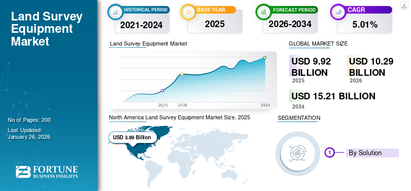
The land survey equipment market size was valued at USD 9.92 billion in 2025. The market is projected to grow from USD 10.29 billion in 2026 to USD 15.21 billion by 2034, exhibiting a CAGR of 5.01%. North America dominated the land survey equipment market with a market share of 39.26% in 2025.
Land surveyors utilize specialized surveying tools to accurately measure objects located on, above, and beneath the Earth's surface, and they possess the authority to determine and define land boundaries. Land surveyors establish the locations of points in two-dimensional or three-dimensional space, along with the distances and angles that connect them. With appropriate tools, land surveyors can ascertain more than just property boundaries, offering the measurements, positioning, and information necessary for various services, such as topographic, mapping & cartographic surveying, geodetic surveying, and utility systems surveying.
The global market for land survey equipment is expected to experience considerable growth in the coming years, driven by key industries such as transportation, energy and power, mining and construction, smart cities forestry, scientific and geological research, precision agriculture, and disaster management utilizing these tools. Significant trends in this sector include a focus on sustainability and eco-friendly options, the integration of smart and connected devices, the creation of user-friendly interfaces, and the incorporation of automation and robotics in surveying.
The global market is fragmented with several global and regional market players. Major players in the industry include Hexagon AB, Samah Aerial Survey Co., Ltd., Shanghai Huace Navigation Technology Ltd., Topcon Corporation, CST/Berger Corporation, Eos Positioning Systems, Inc., Trimble Inc., and U-Blox.
Download Free sample to learn more about this report.
GLOBAL LAND SURVEY EQUIPMENT Market Snapshot & Highlights
Market Size & Forecast:
- 2025 Market Size: USD 9.92 billion
- 2026 Market Size: USD 10.29 billion
- 2034 Forecast Market Size: USD 15.21 billion
- CAGR: 5.01% from 2026–2034
Market Share:
- North America led the market in 2025 with a 39.26% share, fueled by robust infrastructure development, widespread adoption of advanced GNSS systems, and strong defense sector demand.
Key Country Highlights:
- United States: Strong government and defense contracts; growing UAV and GNSS-based surveying applications in infrastructure and mining.
- India: Government-led modernization of land records using drones and rover technology in states like Karnataka.
- China: Rapid urbanization and industrial expansion boosting adoption of surveying tools from domestic firms like CHC Navigation and Hi-Target.
- Japan: Steady demand from precision infrastructure development and land management initiatives.
- UAE & Saudi Arabia: Demand driven by pipeline monitoring and infrastructure growth.
- Brazil & Mexico: Expanding agricultural and industrial sectors fueling land demand and equipment sales.
Market Dynamics
Market Drivers
Increased Accuracy with Advanced Technologies to Catalyze Market Growth
The incorporation of modern technology in land surveying has led to significant advancements, improving precision, productivity, and the overall functionality in the field.
Modern surveying technologies such as GPS, 3D laser scanning, and LiDAR have greatly enhanced measurement accuracy. GPS technology, for instance, can provide accuracy within centimeters, which is vital for determining property lines and conducting precise surveys. Unlike traditional methods, which are prone to human error, digital tools reduce inaccuracies by employing sophisticated measurement methodologies and data gathering approaches.
For instance, in May 2022, the Kerala government opted to forgo the on-site social impact study for the K-Rail SilverLine semi-high-speed rail corridor and instead conducted a GPS-enabled study to improve efficiency.
Digital mapping technologies enhance the surveying process by facilitating remote data gathering and analysis. Surveyors can obtain high-resolution satellite images and existing information without the need for multiple site visits. This approach conserves time and minimizes delays caused by environmental conditions. Tools such as drones are capable of surveying large areas, capturing detailed images that can be processed in real-time, accelerating project schedules.
Geographic Information Systems (GIS) enable surveyors to superimpose various data layers, including topography, infrastructure, and environmental elements. This layered approach improves the understanding of surveyed regions, facilitating more informed decisions during the planning and design stages. The ability to visualize intricate datasets aids in detecting potential conflicts or limitations early in the project lifecycle.
Contemporary technology has transformed land surveying, making it faster and highly efficient. Surveyors can now efficiently gather data with high precision, manage and retrieve the necessary information, and analyze critical features of land in a fraction of time compared to the past.
Market Restraints
Lack of Skilled Labor Could Hamper Market Growth
A major obstacle in the land survey equipment market is the lack of qualified professionals proficient in operating advanced surveying instruments. The sophisticated tools require specialized education and training, which is frequently insufficient in the current workforce. The shortage of trained individuals can result in inefficiencies and mistakes in survey operations, ultimately impacting the success of projects.
Weather variations significantly impact the performance of land surveying equipment. Unfavorable conditions, such as heavy rainfall during monsoon seasons or severe cold, can impede measurement precision and equipment functionality. These fluctuations make it challenging to perform surveys consistently throughout the year.
The expense associated with advanced surveying tools remains a significant obstacle. High equipment prices may discourage investment from smaller companies or those with restricted budgets. This financial challenge limits access to state-of-the-art technology that could improve surveying efficiency.
The complexity of modern land surveying instruments can be daunting for operators who lack sufficient training. Many advanced devices come with numerous functions and operational modes, requiring a thorough understanding and hands-on experience for effective use. This complexity can result in mistakes during data collection and analysis if operators do not receive appropriate training.
Market Opportunity
Integration of Drones With Geographic Information Systems (GIS) for High-Precision Surveys Present Significant Growth Opportunities
Unmanned aerial vehicles equipped with high-resolution cameras and sensors can quickly capture aerial images and topographical data over extensive areas. This capability enables surveyors to obtain data in a fraction of the time required by traditional ground-based techniques.
For instance, tasks that once took days or even weeks can now be completed within hours, facilitating faster decision-making and project execution. The integration of drones with GIS technologies results in highly precise data collection. Drones can deliver detailed aerial imagery, which is then incorporated into GIS platforms for further analysis.
For instance, in January 2025, as part of a comprehensive overhaul of Karnataka's land records and enhancing accuracy, the deputy chief minister has made the first village in the state to finalize a land resurvey employing drone and rover technology.
This initiative enhances mapping accuracy, essential for applications such as urban planning, environmental assessment, and infrastructure development. Furthermore, the incorporation of LiDAR technology with drones significantly improves precision by enabling surveyors to penetrate dense vegetation and capture terrain features, making it invaluable for complex surveying projects.
Combining drone data with GIS systems allows surveyors to carry out detailed spatial analyses. By layering aerial images obtained from drones with existing GIS datasets, the depth and accuracy of spatial analysis are significantly improved. This integration proves to be useful especially in urban planning, disaster management, and land development projects, where comprehending spatial relationships is crucial.
Drones can be programmed to follow predefined flight paths, guaranteeing organized data collection while reducing the risk of human error. This automation streamlines the surveying procedure, improving efficiency, and consistency.
Additionally, combining drone imagery with GIS improves data visualization. Surveyors can develop 3D models and visual displays of land characteristics, which facilitate better comprehension and communication of project specifics among stakeholders. This capability is especially valuable in urban planning, where clear visual representations of proposed developments help engage the public and decision-makers.
LAND SURVEY EQUIPMENT MARKET TRENDS
Technological Advancements in Surveying is a Latest Market Trend
The influence of technology has been felt across various industries and regions, with land surveying benefiting significantly. Advancements in technology have enhanced the accuracy and efficiency of various types of land and boundary surveying. Numerous land surveying firms employ state-of-the-art technology for both residential and commercial surveying, enabling them to achieve optimal results. Below are some technologies used by various companies to meet the land surveying needs.
Satellite Positioning - A key advancement in modern land surveying is the utilization of satellite positioning systems, particularly the Global Navigation Satellite System (GNSS). This system enables surveyors to collect data with exceptional speed and accuracy. By using GNSS receivers, they can precisely determine locations in both two-dimensional and three-dimensional formats. This significantly improves data collection and mapping, decreasing the time required to finish a land survey.
Mapping Software - Mapping software serves as an essential resource for land surveyors. This software integrates aspects of database technology, mapping technology, and geographic coordinates to establish a robust data collection tool that aids surveyors in examining the data gathered with GPS and other surveying instruments.
Laser Scanning - Alongside satellite navigation and mapping applications, laser scanning represents another cutting-edge technology transforming the surveying field. Laser scanners are capable of rapidly and precisely measuring an area, gathering vast amounts of data in a short period. By utilizing laser scanning technology, surveyors can create exceptionally detailed three-dimensional terrain models while capturing changes in elevation and other critical data points.
Unmanned Aerial Vehicles (UAVs) - An important technological innovation in land surveying is the implementation of Unmanned Aerial Vehicles (UAVs). UAVs are remotely operated small aircraft that can be controlled by a pilot or an automated system. These vehicles can gather aerial images of land areas and other locations with high precision, enabling surveyors to efficiently survey vast regions to collect data and achieve their objectives more swiftly.
Download Free sample to learn more about this report.
SEGMENTATION ANALYSIS
By Solution
Increasing need for Improved Data Processing and Analysis to Propel Software Segment Growth
By solution, the market is classified into hardware and software.
The software is estimated to be the fastest-growing segment during the forecast period (2025-2032). The rising demand for enhanced data processing and analysis is a key factor, as contemporary survey software offers advanced capabilities for 3D modeling, geospatial analysis, and data integration, which are critical for precise and thorough land surveys. Additionally, the creation of intuitive interfaces and automated processes makes complex surveying tasks more manageable, promoting the use of advanced software solutions. The incorporation of Augmented Reality (AR) and Virtual Reality (VR) into land surveying processes for visualization, simulation, and training purposes is also contributing to the increased demand for sophisticated software.
The hardware segment will account for the largest market share of 67.79% in 2026. Ongoing improvements in surveying instruments improve their accuracy and dependability. Developments in GNSS technologies, total stations, and drones enable more precise and effective data gathering, making them vital for contemporary surveying activities. There is an increasing need for tough and resilient equipment, particularly for operations in difficult settings such as construction projects and isolated agricultural areas.
By Product
Total Stations Segment Led the Market due to its Adaptability
By product, the market is classified into laser mapping system, UAVs, Mobile Mapping Systems (MMS), and total stations.
The Unmanned Aerial Vehicles (UAVs) segment is witnessing rapid growth during the forecast period due to advancements in aerial video, photo comparisons, 3D site modeling, and aerial photogrammetry, which greatly improves land surveying capabilities. Unmanned Aerial Vehicles (UAVs) are essential in both commercial and defense industries. In commercial contexts, they are crucial for activities such as mapping, surveying, aerial imaging, and photogrammetry.
The casting segment is likely to grow in the upcoming years due to automation of casting processes which has improved production capacity and consistency. Foundries can achieve higher yields with automated systems, making it feasible to meet growing demand in the automotive sector efficiently.
By Technology
Conventional Segment Dominated due to its Affordability
By technology, the market is classified into 2D & 3D scanners, LiDAR, GPS & GNSS, and conventional.
The GPS & GNSS segment is estimated to be the fastest-growing and will account for a 30.24% market share in 2026. The advancement of GPS and GNSS technologies is ongoing, resulting in greater precision in site location, which enhances the accuracy and effectiveness of land surveys. Multi-frequency GNSS receivers improve signal strength and data accuracy, thereby increasing the efficiency of land surveying tools. Contemporary GPS and GNSS systems offer real-time information, even in difficult conditions, which lowers the requirement for intensive labor and decreases the likelihood of mistakes.
The conventional segment accounted for the largest market share in 2024. Traditional surveying technology is generally less expensive than cutting-edge options such as UAVs and sophisticated GNSS systems. For smaller companies or projects with restricted budgets, purchasing conventional equipment may be a more practical choice, offering sufficient accuracy for numerous applications.
To know how our report can help streamline your business, Speak to Analyst
By Industry
Mining & Construction Segment Led due to the Development in Emerging Countries
By industry, the market is classified into transportation, scientific & geological research, energy & power, precision agriculture, mining & construction, disaster management, forestry, and others.
Precision agriculture segment is estimated to depict the fastest-growth during the forecast period (2025-2032). The growing use of advanced technologies such as GNSS systems, drones, and total stations in precision agriculture plays a crucial role in driving market expansion, as farmers and agricultural experts employ these sophisticated tools for activities such as land leveling and irrigation planning. Progress in land surveying has enhanced accuracy, efficiency, and precision, which facilitates improved decision-making in urban development, natural resource management, and environmental oversight.
By Application
Monitoring Segment Led due to Rising Renewable Energy Initiatives
By application, the market is classified into inspection, layout points, monitoring, volumetric calculations, and others.
The monitoring segment accounted for the largest market share in 2024. Governments are putting resources into infrastructure projects, increasing the demand for land survey equipment used for leveling, grading, and building. The monitoring process is essential in renewable energy initiatives, assessing site feasibility, improving layout design, and guaranteeing adherence to regulations for better energy production.
Inspection is estimated to be the fastest-growing segment during the forecast period of 2025-2032. Technological advancement in land survey greatly enhances inspection applications by improving accuracy, efficiency, and precision, which leads to better decision-making in areas such as urban planning, resource management, and environmental oversight. Furthermore, the incorporation of drones in inspection processes allows for the collection of images and videos, offering real-time visual data with minimal human involvement, which fuels market growth.
By End User
Rising defense based contracts for land survey equipment will propel the market growth
By end user, the market is classified into defense, industrial, commercial, and government.
The defense segment accounted for the largest market share in 2024. Defense contracts increasingly include procurement of advanced hardware such as GNSS systems, total stations, UAVs (drones), and 3D laser scanners, which are critical for precise geospatial data collection in military contexts. The UK Ministry of Defence awarded USD 2.22 million in contracts to SMEs for developing semi-autonomous reconnaissance and survey systems to assist Army engineers in crossing natural obstacles, highlighting a trend toward automation and remote surveying to enhance troop safety and operational speed.
Commercial segment is expected to be the fastest growing segment during forecast period. Majorly used in domain such as construction, agriculture, mining, and infrastructure development, for tasks like mapping, property boundary determination, and site planning.
LAND SURVEY EQUIPMENT REGIONAL AND COUNTRY OUTLOOK
By region, the market is classified into North America, Europe, Asia Pacific, and the rest of the world.
North America Land Survey Equipment Market Size, 2025 (USD Billion)
To get more information on the regional analysis of this market, Download Free sample
North America
The North America market generated USD 3.89 billion in 2025, representing 39.26% of the global market landscape, and is expected to reach USD 4.01 billion in 2026, driven by technological advancements, infrastructure modernization, and the increasing adoption of advanced surveying tools. The integration of drones, advanced GNSS systems, and GIS technology is improving surveying capabilities and accuracy. In the U.S., the market for land survey equipment is expanding rapidly, primarily due to the demand from the defense and mining sectors. Additionally, there is a growing use of these tools in urban areas to enhance planning processes. Major companies in the market include Hexagon AB, Trimble Inc., Topcon Corporation, and others, all of which hold substantial market shares in the region. The U.S. market is projected to reach USD 2.96 billion by 2026.
Asia Pacific
Asia Pacific accounted for USD 2.9 billion in 2025, representing 29.23% of the global market share, and is projected to reach USD 3.05 billion in 2026. In Asia Pacific, land survey equipment market growth is estimated to be the fastest-growing during the forecast period driven by rapid urbanization, infrastructure development, and the adoption of advanced technologies. Growing urbanization and industrialization are increasing the demand for land survey equipment and the region is witnessing a rise in population and high disposable income, leading to increased demand for products and growth in the industrial and agricultural sectors. In addition, the increasing construction of highways, growing urbanization, rail and road transportation projects, and power plants in the region will increase the demand for land survey equipment. Furthermore, new technologies, such as UAV, GNSS, and laser scanners integrated into land survey equipment, are expected to increase demand in the market. Key players operating in the market include GUANGDONG KOLIDA INSTRUMENT CO., LTD; Changzhou Dadi Surveying Science & Technology; Hi, and others. The Japan market is projected to reach USD 0.17 billion by 2026, the China market is projected to reach USD 1.33 billion by 2026, and the India market is projected to reach USD 0.93 billion by 2026.
Europe
Europe contributed 21.55% to the global market in 2025, with a valuation of USD 2.14 billion, and is projected to reach USD 2.22 billion in 2026. Europe’s market for land survey equipment is witnessing significant growth, driven by regulatory frameworks and government initiatives aimed at enhancing land management and urban development. Moreover, progress in data collection technologies is also fueling this growth, as leading players in the industry focus on technological advancements and broadening their product offerings to capture substantial market demand. Additionally, key companies are making substantial investments in innovation to improve the precision and efficiency of their products, integrating features such as GPS, 3D scanning, and advanced data analytics. Companies operating in the region are employing strategies such as partnerships, new product launches, and acquisitions to expand their market presence and capitalize on complementary technologies. The UK market is projected to reach USD 0.37 billion by 2026, while the Germany market is projected to reach USD 0.31 billion by 2026.
rest of the world
In 2025, the Rest of the World market stood at USD 0.99 billion, representing 9.96% of global demand, and is projected to grow to USD 1.01 billion in 2026. The rest of the world’s market is primarily influenced by drilling and pipeline management activities in the Middle East & Africa, which are enhancing the need for precise geographic data mapping and boosting the land survey equipment industry.
Latin America
Latin America is witnessing steady expansion, fueled by growth in its industrial and agricultural sectors, leading to a higher demand for land and subsequently driving sales of land survey equipment.
COMPETITIVE LANDSCAPE
Key Market Players
Key Participants are Concentrating on Incorporating Cutting-Edge Technologies to Establish a Solid Presence
The market for land survey equipment is quite competitive and somewhat fragmented. Leading companies employ strategies such as mergers, acquisitions, and developing new products to secure a competitive advantage and expand their global presence. Major players in the land survey equipment industry are focusing on integrating advanced technologies to create a strong foothold. Major companies have chosen product launches and acquisitions as their primary development strategies to enhance their product offerings. Moreover, they are increasing their operations in emerging regions such as India and China to take advantage of opportunities arising from rapid infrastructure development and urbanization. For instance, in July 2024, Karnataka announced plans to upgrade the land survey process by ensuring that GPS technology-based equipment is available in all for conducting land surveys.
LIST OF KEY LAND SURVEY EQUIPMENT COMPANIES PROFILED
- Hexagon AB (Sweden)
- Trimble Inc. (U.S.)
- Topcon Corporation (Japan)
- CHC Navigation (China)
- Hi-Target (China)
- U-Blox Holdings AG (Switzerland)
- Hudaco Industries (South Africa)
- GEOTECH 3D (UAE)
- Geosolution I Goteborg Ab (Sweden)
- Global GPS Systems (Netherlands)
KEY INDUSTRY DEVELOPMENTS
- May 2024 - Aerial electromagnetic surveys are scheduled for northwest Kansas from late May to early June as part of a collaborative initiative to evaluate the state of the Ogallala aquifer. The Kansas Geological Survey, affiliated with the University of Kansas, is involved in this project.
- October 2024 - Penn State Wilkes-Barre has been granted a donation from the Pennsylvania Land Surveyors’ (PLS) Foundation, allowing the program to acquire more equipment. The contribution of USD 5,000 was utilized to buy two Leica CS-20 field data collectors, increasing the total number of new data collectors to eight.
- May 2024 - A scientist from HVO is installing temporary GPS equipment to the south of Kaluapele, with the long profile of Mauna Loa volcano visible in the background. By analyzing data from previous eruptions, researchers can obtain crucial insights into the patterns and cycles of a volcano. This understanding enhances our ability to anticipate a volcano's activity, allowing us to effectively convey potential risks to surrounding communities. The primary geophysical tools utilized today for monitoring changes and unrest in volcanoes include Global Positioning System (GPS), borehole tiltmeters, Interferometric Synthetic Aperture Radar (InSAR), and seismometers. These modern instruments have superseded older surveying tools that were employed in earlier times.
- September 2024 - Prudent Engineering LLP, a firm specializing in various civil engineering and land surveying disciplines, has appointed Christopher Hansen as the assistant project manager for the land survey division. Hansen brings with him 20 years of experience in land surveying.
- July 2022 - Narayanpet District Collector Harichandana examined the new survey tool 'Geode' presented by the district survey officials. Officials to utilize the advanced technology effectively to carry out the land survey and establish accurate boundaries for all government properties in the district.
REPORT COVERAGE
The research report provides a detailed analysis of the market insights and focuses on important aspects, such as key players, applications depending on various regions and countries. Moreover, it offers insights into the market trends, competitive landscape, market competition, comparative analysis, and highlights key industry developments. Additionally, it encompasses several factors that have contributed to the expansion of the global market in recent years.
Request for Customization to gain extensive market insights.
Report Scope & Segmentation
|
Study Period |
2021-2034 |
|
Base Year |
2025 |
|
Estimated Year |
2026 |
|
Forecast Period |
2026-2034 |
|
Historical Period |
2021-2024 |
|
Growth Rate |
CAGR of 5.01% from 2026 to 2034 |
|
Unit |
Value (USD Billion) |
|
Segmentation |
By Solution
|
|
By Product
|
|
|
By Technology
|
|
|
By Industry
|
|
|
By Application
|
|
|
By End-User
|
|
|
By Region
|
Frequently Asked Questions
As per the Fortune Business Insights study, the market size was valued at USD 9.92 billion in 2025 and is anticipated to USD 15.21 billion by 2034.
The market is likely to grow at a CAGR of 5.01% during the forecast period (2026-2034).
The top players in the industry are Hexagon AB (Sweden), Trimble Inc. (U.S.), and Topcon Corporation (Japan).
North America dominates the market.
The Asia Pacific region is estimated to be the fastest growing during the forecast period.


- 2021-2034
- 2025
- 2021-2024
- 200
Get 30-60 hrs Free Customization
Expand Regional and Country Coverage, Segments Analysis, Company Profiles, Competitive Benchmarking, and End-user Insights.
-
US +1 833 909 2966 ( Toll Free )
-
Get In Touch With Us